Home --> Destinations --> Karoo --> Prieska

Prieska
Including Copperton

Location: 240km southwest of Kimberley on the R357.

Region: Karoo

Nearby Towns: Copperton, Douglas, Marydale, Britstown, Vosburg, Hopetown

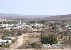
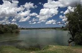
On the south bank of the Orange River at the foot of the Doringberg, it was originally named Prieschap, a Khoisan word meaning ‘place of the lost she-goat’. 

The site of the town, founded in 1882 and renowned for its semiprecious stones, was a fording place used by early travellers.

Location Prieska: 

Map Prieska: 

Accommodation Prieska

currently unavailable

see available accommodation 

 Explore Prieska

 Die Bos Nature Reserve 
Indigenous trees, shrubs and abundant bird life, picnic spots and angling. Suspended bridges cross the Prieska River. 
 Fort 
On top of Prieska Koppie, built with tiger’s eye by the British during the Anglo-Boer War (1899-1902).
Khoisan Rock Art 
Kleindoring, Omdraaisvlei, Uitdraai and Wonderdraai
Memorial Garden 
In town, it contains graves of British soldiers killed during the Anglo-Boer War.
Green Valley Nuts 
Cultivation and export of Pistachio Nuts.
 Hiking Trails
The Oranjezicht and T’Keikamspoort hiking trails are 10km south of town in the Doornberge.
Prieska Museum 
A skillful display of the yesteryear Prieska.
Ria Huysamen Aloe Garden 
A large array of succulents. The area between Prieska and Vioolsdrif is often called the ‘Rock Garden Route’ - the rare halfmens and succulents of the Lithops family are found here.
Schumann Rock Collection 
Includes semiprecious stones and San stone implements at the municipal offices.
Wonderdraai
A wonderful freak of nature where a horseshoe-shaped island is formed by the flow of the Orange River and makes it seem as if the river turns to flow uphill.